![](/images/other/stat-length.png)
![Tour Wandern La Chapelle-en-Valgaudémar - Valgaudemar - Gioberney Refuge de Vallonpierre - 16km 850m 5h35 - 2018 07 03 - public - Photo](https://media.geolcdn.com/t/1900/400/ext.pjpeg?maxdim=2&url=https%3A%2F%2Fmedia.geolcdn.com%2Ff%2Fb31b91c8-a8b7-444d-8b10-22f70d1d8991.jpg)
Valgaudemar - Gioberney Refuge de Vallonpierre - 16km 850m 5h35 - 2018 07 03 - public
Orcal37
Benutzer GUIDE
![Länge](/images/other/stat-length.png)
Länge
16 km
![Maximale Höhe](https://static1.geolcdn.com/siteimages/upload/files/1508320355ic_sort_altitude_max_24dp.png)
Maximale Höhe
2290 m
![Positive Höhendifferenz](https://static1.geolcdn.com/siteimages/upload/files/1508320355ic_sort_den_pos_24dp.png)
Positive Höhendifferenz
852 m
![Km-Effort](/images/other/stat-length.png)
Km-Effort
27 km
![Min. Höhe](https://static1.geolcdn.com/siteimages/upload/files/1508320355ic_sort_altitude_min_24dp.png)
Min. Höhe
1518 m
![Negative Höhendifferenz](https://static1.geolcdn.com/siteimages/upload/files/1508320355ic_sort_den_neg_24dp.png)
Negative Höhendifferenz
862 m
![Boucle](https://static1.geolcdn.com/siteimages/upload/files/16400158638029165_repeat_loop_refresh_sync_direction_icon.png)
Boucle
Ja
Erstellungsdatum :
2019-01-15 12:32:36.386
Letzte Änderung :
2021-09-09 16:05:42.052
![Wandern](https://static1.geolcdn.com/sitytour/trail-icons/101.png)
7h35
Schwierigkeit : Schwierig
![Scannen Sie diesen QR-Code, um die Tour in der SityTrail-Anwendung zu öffnen](https://capi.geolives.com/qq0zvz2zws4bq2lad0pu/sitytour/trails/998684/qr.png?size=200)
Kostenlosegpshiking-Anwendung
Über SityTrail
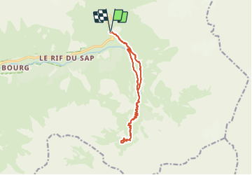
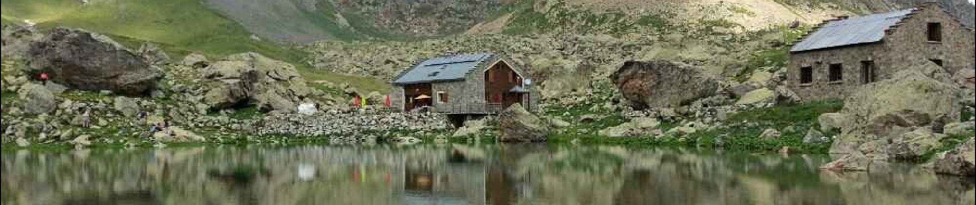
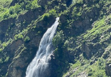
Tour Wandern von 16 km verfügbar auf Provence-Alpes-Côte d'Azur, Hochalpen, La Chapelle-en-Valgaudémar. Diese Tour wird von Orcal37 vorgeschlagen.
Beschreibung
Valgaudemar - de Gioberney (du parking du Crépon) au Refuge de Vallonpierre - 16km 850m 5h35 - 2018 07 03 - public
Ort
Land:
France
Region :
Provence-Alpes-Côte d'Azur
Abteilung/Provinz :
Hochalpen
Kommune :
La Chapelle-en-Valgaudémar
Standort:
Unknown
Gehen Sie:(Dec)
Gehen Sie:(UTM)
285194 ; 4968282 (32T) N.
Kommentare
Touren in der Umgebung
![Tour Wandern La Chapelle-en-Valgaudémar - Tour du Vieux Chaillol 2/5 - Du Gîte Le Casset au Refuge de Vallonpierre - Photo](https://media.geolcdn.com/t/375/260/ext.jpg?maxdim=2&url=https%3A%2F%2Fservices.sitytrail.com%2FGeolivesWS%2FDownloadMedia.ashx%3FTrailID%3D110181%26Media%3D5395_2.jpg)
![Wandern Wandern](https://static1.geolcdn.com/sitytour/trail-icons/101.png)
Tour du Vieux Chaillol 2/5 - Du Gîte Le Casset au Refuge de Vallonpierre
Wandern
Medium
(1)
La Chapelle-en-Valgaudémar,
Provence-Alpes-Côte d'Azur,
Hochalpen,
France
![](/images/other/stat-length.png)
11,8 km | 24 km-effort
4h 30min
![](https://static1.geolcdn.com/siteimages/upload/files/16400158638029165_repeat_loop_refresh_sync_direction_icon.png)
Nein
![Tour Wandern La Chapelle-en-Valgaudémar - Valgaudemar - Gioberney Lac du Lauzon - 7.3km 490m 2h45 - 2018 06 27 - public - Photo](https://media.geolcdn.com/t/375/260/ext.jpg?maxdim=2&url=https%3A%2F%2Fservices.sitytrail.com%2FGeolivesWS%2FDownloadMedia.ashx%3FTrailID%3D999345%26Media%3Dfix__20180627142404.jpg)
![Wandern Wandern](https://static1.geolcdn.com/sitytour/trail-icons/101.png)
Valgaudemar - Gioberney Lac du Lauzon - 7.3km 490m 2h45 - 2018 06 27 - public
Wandern
Schwierig
La Chapelle-en-Valgaudémar,
Provence-Alpes-Côte d'Azur,
Hochalpen,
France
![](/images/other/stat-length.png)
7,2 km | 13,6 km-effort
4h 30min
![](https://static1.geolcdn.com/siteimages/upload/files/16400158638029165_repeat_loop_refresh_sync_direction_icon.png)
Ja
![Tour Wandern La Chapelle-en-Valgaudémar - Valgaudemar - Rif du Sap Le Clot - 6km 190m 1h45 - 2018 07 04 - public - Photo](https://media.geolcdn.com/t/375/260/ext.jpg?maxdim=2&url=https%3A%2F%2Fservices.sitytrail.com%2FGeolivesWS%2FDownloadMedia.ashx%3FTrailID%3D998794%26Media%3Dfix__20180704131615.jpg)
![Wandern Wandern](https://static1.geolcdn.com/sitytour/trail-icons/101.png)
Valgaudemar - Rif du Sap Le Clot - 6km 190m 1h45 - 2018 07 04 - public
Wandern
Medium
La Chapelle-en-Valgaudémar,
Provence-Alpes-Côte d'Azur,
Hochalpen,
France
![](/images/other/stat-length.png)
6 km | 8,5 km-effort
2h 20min
![](https://static1.geolcdn.com/siteimages/upload/files/16400158638029165_repeat_loop_refresh_sync_direction_icon.png)
Ja
![Tour Wandern La Chapelle-en-Valgaudémar - PARC NATIONAL DES ECRINS: REFUGE DU PIGEONNIER - Photo](https://media.geolcdn.com/t/375/260/ext.jpg?maxdim=2&url=https%3A%2F%2Fmedia.geolcdn.com%2Ff%2F63f96214-74ba-423a-b110-db305c3e34c6.jpg)
![Wandern Wandern](https://static1.geolcdn.com/sitytour/trail-icons/101.png)
PARC NATIONAL DES ECRINS: REFUGE DU PIGEONNIER
Wandern
Medium
La Chapelle-en-Valgaudémar,
Provence-Alpes-Côte d'Azur,
Hochalpen,
France
![](/images/other/stat-length.png)
9,4 km | 21 km-effort
3h 22min
![](https://static1.geolcdn.com/siteimages/upload/files/16400158638029165_repeat_loop_refresh_sync_direction_icon.png)
Ja
![Tour Zu Fuß La Chapelle-en-Valgaudémar - Refuge du Pigeonnier - Photo](https://media.geolcdn.com/t/375/260/ext.jpg?maxdim=2&url=https%3A%2F%2Fmedia.geolcdn.com%2Ff%2Fce7c5daf-99aa-48e8-b5ea-75a2997b18fd.jpg)
![Zu Fuß Zu Fuß](https://static1.geolcdn.com/sitytour/trail-icons/100.png)
Refuge du Pigeonnier
Zu Fuß
Schwierig
La Chapelle-en-Valgaudémar,
Provence-Alpes-Côte d'Azur,
Hochalpen,
France
![](/images/other/stat-length.png)
7,8 km | 18,6 km-effort
4h 13min
![](https://static1.geolcdn.com/siteimages/upload/files/16400158638029165_repeat_loop_refresh_sync_direction_icon.png)
Ja
![Tour Zu Fuß La Chapelle-en-Valgaudémar - Refuge de Vallonpierre - Photo](https://media.geolcdn.com/t/375/260/ext.jpg?maxdim=2&url=https%3A%2F%2Fmedia.geolcdn.com%2Ff%2F16d7efaa-2103-48b0-a321-9af1c50d5cf9.JPG)
![Zu Fuß Zu Fuß](https://static1.geolcdn.com/sitytour/trail-icons/100.png)
Refuge de Vallonpierre
Zu Fuß
Schwierig
La Chapelle-en-Valgaudémar,
Provence-Alpes-Côte d'Azur,
Hochalpen,
France
![](/images/other/stat-length.png)
13,8 km | 24 km-effort
5h 33min
![](https://static1.geolcdn.com/siteimages/upload/files/16400158638029165_repeat_loop_refresh_sync_direction_icon.png)
Ja
![Tour Wandern La Chapelle-en-Valgaudémar - Refuge de Chalance - Photo](https://media.geolcdn.com/t/375/260/ext.jpg?maxdim=2&url=https%3A%2F%2Fmedia.geolcdn.com%2Ff%2F1a6ccd9d-04ac-4e77-8122-f521b62c6988.JPG)
![Wandern Wandern](https://static1.geolcdn.com/sitytour/trail-icons/101.png)
Refuge de Chalance
Wandern
Schwierig
La Chapelle-en-Valgaudémar,
Provence-Alpes-Côte d'Azur,
Hochalpen,
France
![](/images/other/stat-length.png)
7,5 km | 22 km-effort
5h 1min
![](https://static1.geolcdn.com/siteimages/upload/files/16400158638029165_repeat_loop_refresh_sync_direction_icon.png)
Ja
![Tour Zu Fuß La Chapelle-en-Valgaudémar - Refuge de Chabournéou - Photo](https://media.geolcdn.com/t/375/260/ext.jpg?maxdim=2&url=https%3A%2F%2Fmedia.geolcdn.com%2Ff%2F25007c95-3b8c-48fb-a1ed-beb94d3d1e7a.JPG)
![Zu Fuß Zu Fuß](https://static1.geolcdn.com/sitytour/trail-icons/100.png)
Refuge de Chabournéou
Zu Fuß
Medium
La Chapelle-en-Valgaudémar,
Provence-Alpes-Côte d'Azur,
Hochalpen,
France
![](/images/other/stat-length.png)
10,2 km | 17,1 km-effort
3h 53min
![](https://static1.geolcdn.com/siteimages/upload/files/16400158638029165_repeat_loop_refresh_sync_direction_icon.png)
Ja
![Tour Wandern La Chapelle-en-Valgaudémar - Valgo 2 - J6 : refuge du Pigeonnier - Photo](https://media.geolcdn.com/t/375/260/ext.jpg?maxdim=2&url=https%3A%2F%2Fmedia.geolcdn.com%2Ff%2Fc6689721-e653-43be-95d0-5a3d660e8f8a.jpg)
![Wandern Wandern](https://static1.geolcdn.com/sitytour/trail-icons/101.png)
Valgo 2 - J6 : refuge du Pigeonnier
Wandern
Schwierig
La Chapelle-en-Valgaudémar,
Provence-Alpes-Côte d'Azur,
Hochalpen,
France
![](/images/other/stat-length.png)
13,4 km | 27 km-effort
4h 15min
![](https://static1.geolcdn.com/siteimages/upload/files/16400158638029165_repeat_loop_refresh_sync_direction_icon.png)
Ja